
Sign In
By signing in or creating an account, you agree with Associated Broadcasting Company's Terms & Conditions and Privacy Policy.
By signing in or creating an account, you agree with Associated Broadcasting Company's Terms & Conditions and Privacy Policy.


The NASA-ISRO Synthetic Aperture Radar (NISAR) satellite is the first collaboration of its kind between NASA's Jet Propulsion Laboratory (JPL) in California and ISRO's Space Applications Centre (SAC) in Ahmedabad. ISRO is providing the S-band radar, while NASA is providing the L-band radar, which both use the same 12 metre wide radar reflector antenna. The exquisite precision of the instruments on board will allow scientists to monitor centimetre-scale motions on the surface of the Earth, allowing scientists to track land movements associated with earthquakes, volcanoes and landslides, better understand and predict these disasters, and improve disaster response operations. The satellite will be able to provide a complete picture of both the horizontal and vertical movements of sea ice, glaciers and ice sheets as well.
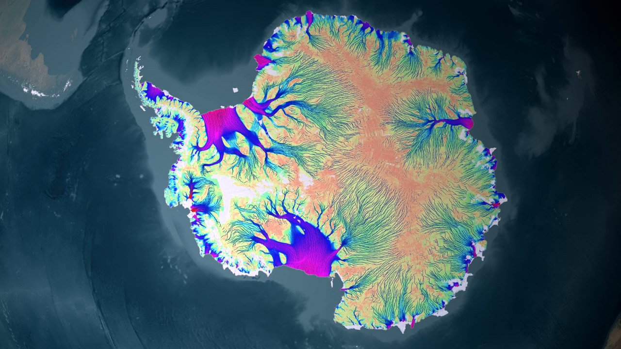
Visualisation of Antarctic ice motion. (Image Credit: NASA/GSFC/SVS)
Yashas Karnam, cofounder and COO of Bellatrix Aerospace says, "The collaborative effort shown by ISRO in providing the launch service and the S-band SAR, and NASA providing the L-band SAR on this project truly exemplifies what global cooperation focused on the well-being of our planet should look like. What sets NISAR apart technically is its interferometric SAR (InSAR) capability, which will provide a meter-scale resolution. It marks a shift in our ability to model, mitigate, and adapt to climate change and natural disasters. In many ways, it stands as a civilizational asset, providing foresight and data necessary to potentially avert the impacts of natural and anthropogenic threats. For space tech startups, this represents a turning point. NISAR’s data will fuel research and drive sustainable development. It’s not just a science mission, it’s a living laboratory for next-gen EO platforms, where sensing, autonomy, and onboard data processing converge at scale. This mission also signals a potential openness from both the Indian and US governments to pursue similar collaborations between private space companies in their respective nations"
The NISAR satellite has the capability of mapping the entire surface of the Earth every 12 days. NISAR will be able to monitor remote Earthquake-prone regions of the world that are not monitored or studied. NISAR will also be able to measure the deformations of the land around volcanoes, which may signal imminent activity. The sensitivity of NISAR also allows for the monitoring of groundwater levels. The data captured by the mission will also be able to monitor the health of wetlands and forests. Scientists around the world will get a much better idea of the cryosphere of the planet, and track the movements of ice sheets in Antarctica and Greenland. This aspect of the mission is important to India because of its extensive coastline, and the observations will allow researchers to better predict global sea level rise.

ISRO and NASA technicians posing with the NISAR satellite at the UR Rao Satellite Centre in Bengaluru in June 2023. (Image Credit: VDOS/URSC).
The radar instruments can function in the day and night, and peer through obscuring clouds. The data captured from the mission will be available free of cost to everyone on the planet. ISRO will be making the data available through its Bhoonidhi geoinformatics portal, while NASA is using Amazon Web Services to rapidly process, store and distribute the data through the cloud, making it available within four days of capture. The NISAR satellite is expected to capture around 80 terabytes of data per day. Both ISRO and NASA will be making the data from both payloads available publicly. ISRO is launching the NISAR satellite on its GSLV-F16 rocket on 30 July, 2025 from the second launch pad at its Sriharikota Spaceport at 17:40 hours IST.


